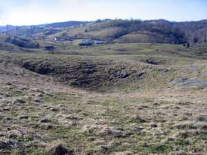
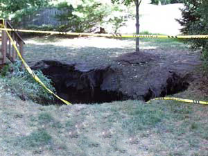
Sinkholes are bowl-shaped, funnel-shaped, or vertical-sided depressions in the land surface that form over underground voids. These depressions can range from a few feet to several hundred feet in diameter, and usually result from the natural collapse of soluble bedrock and overlying soil. Sinkholes can also result from mining, groundwater pumping, and leaking water, sewer, and storm water pipes. Subsidence of the ground is usually gradual, but occasionally it can be sudden and dramatic.
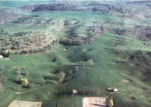
When it rains, a portion of the slightly acidic water percolates though the soil, encounters bedrock, and slowly dissolves mineral grains. In regions of carbonate bedrock, this process can create underground fissures and caves. The surface of such a region is often pocked with depressions called sinkholes. Sinkholes are a characteristic feature of a karst terrain. In well-developed karst terrain, chains of sinkholes form what are known as solution valleys and streams frequently disappear underground.
Sinkhole collapse, either slow or dramatic, can cause considerable damage to buildings, highways, rails, bridges, pipelines, storm drains, and sewers. In addition, sinkholes provide a pathway for surface water to directly enter groundwater aquifers. The increasing potential for pollution is particularly high due to the minimal filtering of surface water.
A poor understanding of karst terrain has led to land-use practices that pose significant economic and environmental impacts to households and communities. Sinkhole formation is closely related to local hydrological conditions, and human-induced changes to the local hydrology can accelerate the process. Diverting surface water, pumping groundwater, and constructing reservoirs can all contribute to sinkhole formation. An extreme example occurred in Florida on February 25, 1998, when, during the flushing of a newly drilled irrigation well, hundreds of sinkholes up to 150 feet across formed over a twenty-acre area within a few hours. Runaway urbanization and development dramatically increases water usage, alters drainage pathways, and overloads the ground surface. According to the Federal Emergency Management Agency, the number of human-induced sinkholes has doubled since 1930, while insurance claims for related damages has increased 1,200 % from 1987 to 1991, costing nearly $100 million. Subsidence is generally not covered by a standard homeowner's insurance policy.
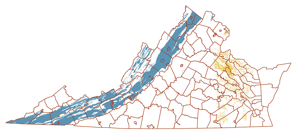
Areas in Virginia underlain by bedrock containing carbonate material (blue) and unconsolidated sediments of the Chesapeake Group (yellow).
In Virginia, the principal area affected by sinkholes is the Valley and Ridge Province, an extensive karst terrain underlain by limestone and dolomite. Narrow marble belts also occur in the Piedmont Province. Sinkholes are also sometimes present in the Coastal Plain Province, in areas underlain by shelly beds in the Yorktown Formation of the Chesapeake Group. Dramatic collapses that swallow homes or persons have happened in Virginia, but are rare. The most notable incidents occurred in the City of Staunton: on August 11, 1910, parts of several homes and the firehouse were lost in a series of sinkholes on Baldwin Street and Central Avenue, and on October 28, 2001, a 45-feet deep chasm opened up on Lewis Street. In April of 2000, thirty-two sinkholes were reported in the upper Shenandoah Valley after seven inches of rain fell after a long dry spell.
Sinkholes sometimes cause problems for transportation infrastructure in the Commonwealth. During the past thirty years, VDOT has recorded approximately 500 sinkholes that have damaged roads throughout the state. In March 2001, a nine-mile stretch of Interstate 81 in Augusta County was closed after the sudden appearance of three sinkholes, the largest measuring 20 feet long, 11 feet wide and 22 feet deep. On October 5, 2004, the right southbound lane of I-81 just north of the Exit 118C ramp in Montgomery County collapsed. Due to the potential for damage to infrastructure and danger to the travelling public, VDOT maintains an emergency contract for sinkhole repair. In general, sinkhole occurrence is unpredictable and the size of a sinkhole cannot be estimated from the surface collapse, so repair costs range from the tens of thousands to the hundreds of thousands of dollars per sinkhole. Research into sinkhole distribution and early prediction is ongoing; however, a true method of early prediction remains elusive.
Groundwater contamination is a common problem in populated areas overlying karst terrain. Karst aquifer contaminants in Virginia have included petroleum products, herbicides, solvents, fertilizers, sheep and cattle dip, sewage, dead livestock, and household garbage. In the late 1800s, a Shenandoah County community was subjected to a cholera outbreak due to the pollution of the local karst aquifer. A significant concern is the vulnerability of karst aquifers to contamination along the I-81 corridor, where hazardous materials are regularly transported and accidents can occur. For some chemicals that do not readily mix with water, contamination can be widespread and remain in the groundwater for many years. Most of Virginia’s karst region follows Interstate 81, and twenty-seven of Virginia’s counties lie in this zone, where hundreds of thousands of people get their drinking water from wells and springs.
State law prohibits the dumping of waste into sinkholes, and some Virginia counties have implemented ordinances about sinkhole dumping and outfalls. Meanwhile, the Virginia Department of Health oversees numerous wells and springs in the karst areas of western Virginia that it permits for use as public and private water supplies. The Virginia Department of Conservation and Recreation’s Natural Heritage Karst Program ocuments the numerous (>200) rare and highly endemic species associated with Virginia's caves and karst, and coordinates the protection and conservation of their habitat. The US Geological Survey has coordinated with various state agencies, working with various state agencies to develop a National Karst Map, and maintains a state Water Science Center that includes numerous monitoring stations at karst springs and wells across Western Virginia.
Areas over historic underground mine workings are also susceptible to subsidence. Mine collapses have resulted in losses of homes, roadways, utilities and other infrastructure. Abandoned coal mines occur in Buchanan, Dickenson, Lee, Scott, Russell, Tazewell, Wise, Montgomery, and Pulaski counties in southwest Virginia; and Henrico, Chesterfield and Goochland counties in the Richmond coal basin. Other abandoned underground mines occur throughout the state. Information of past mining activity can be obtained from the Mineral Mining Program and Abandoned Mined Land Program.
Recently, our geologists have started using high-resolution LiDAR data to map sinkhole locations and help identify geologic units prone to sinkhole collapse. LiDAR, which stands for Light Detection and Ranging, is a method of remote sensing that can produce a precise 3-dimensional model of the Earth's surface. Unlike aerial imagery like you would find on Google Earth, LiDAR can see beyond dense vegetation and forest cover to reveal the extent of sinkholes and even subtle depressions on the earth's surface. Inventorying sinkholes can be an arduous, time-consuming task. To speed things along, geoscientists have starting using LiDAR data to automatically detect and delineate sinkholes using computer programs.
Signs of Sinkhole Formation:
Although a sinkhole can form without warning, specific signs can signal potential development:
- Slumping or falling fence posts
- Wilting vegetation
- Discolored well water
- Structural cracks in walls, floors, or foundations.
- Cracks in soil/subsidence.
Resources:
- Caving In Virginia Fact Sheet
- Sinkholes In Virginia Fact Sheet
- Map showing the distribution of carbonate bedrock
- Map showing distribution of Chesapeake Group sediments
- GIS geodatabase showing the distribution of sinkholes and other depressions derived from topographic maps and aerial photographs (not field verified)
- Open-file report 2023-01, containing a GIS geodatabase and shapefiles showing the distribution of carbonate bedrock and Chesapeake Group sediment
- Open-file report 2022-10, Phase I derivative geologic map database of karst geology in the I-81 Corridor
- Virginia Department of Conservation and Recreation
- Virginia Cave Board
Selected References:
Fosse, R. M., 1968, Surface subsidence and collapse caused by groundwater withdrawal in carbonate rock areas: Proceedings of the 23rd International Geological Congress, Prague, v. 12, p. 155-166.
Hubbard, D. A., Jr., 1983, Selected karst features of the northern Valley and Ridge province, Virginia: Virginia Division of Mineral Resources, Publication 44, one sheet.
Hubbard, D. A., Jr., 1988, Selected karst features of the central Valley and Ridge province, Virginia: Virginia Division of Mineral Resources, Publication 83, one sheet.
Hubbard, D. A., Jr., 1999, Highways in Virginia karst: Resource and hazard considerations: 50th Annual Highway Geology Symposium & TRB Karst Meeting, Proc. & Field Trip Guide, 13-22.
Hubbard, D. A., Jr., 2001, Selected karst features of the southern Valley and Ridge province, Virginia: Virginia Division of Mineral Resources, Publication 167, one sheet.
Hubbard, D. A., Jr., 2003, Use of regional sinkhole mapping for sinkhole susceptibility maps, in Beck, B. F., ed., ASCE Geotechnical Special Publication No. 122, p. 61-71.
Hubbard, D. A., Jr. and Sterrett, R. M., 1994, Groundwater contamination in Virginia karst: Case studies (abs.): Program and Abstracts, 37th Annual Meeting of the Association of Engineering Geologists, Williamsburg, VA, p. 49.
Sowers, G. F., 1976, Mechanisms of subsidence due to underground opening, in Subsidence over mines and caverns, moisture and frost actions, and classification: Washington D.C., Transportation Research Board Record 612, National Academy of Science, p. 2-8
Weary, D.J., 2008. Preliminary Map of Potentially Karstic Carbonate Rocks in the Central and Southern Appalachian States: USGS Open-File Report 2008-1154 http://pubs.usgs.gov/of/2008/1154/