Radon is a colorless, odorless, radioactive gas derived from the decay of uranium along with thorium, radium, and other radioactive elements that naturally occur in granites as well as some metamorphic and sedimentary rocks. As radon gas is released from bedrock, it migrates upward through the soil and can seep into the basements of houses and other buildings through dirt floors, cracks in concrete, and floor drains. Radon has a tendency to accumulate in enclosed spaces such as buildings.
Radon is a significant indoor air contaminant that is the second leading cause of lung cancer in the U.S., with 15,000 related deaths per year. Employees who work in basements and lower floor levels and inhale elevated levels of radon for extended periods are at particular risk. A report by the National Academy of Sciences confirms that radon in drinking water is also a serious public health threat. Not only does radon pose human health risks, but there are also potential economic impacts for housing markets and businesses in areas with severe radon problems.
Migration and concentration of radon is extremely variable, and depends on the amount of radioactive material in the bedrock, soil moisture content, groundwater circulation, and atmospheric pressure gradients. Uranium is widespread in the Earth’s crust, but its distribution is non-uniform — concentrations are generally high in granite, rhyolite, and shale, generally low in sandstone, basalt, and gabbro, while carbonate rocks exhibit a broad range and ultramafic rocks have the lowest radioactivity level of all. However, uranium is highly mobile in groundwater and can move considerable distances and be re-deposited at higher concentrations than the original occurrence. Permeable sandstone that contains pyrite and organic material (setting up a reducing environment) frequently acts as host rock. Uranium can also be concentrated along faults. Thorium occurs in heavy mineral placer sands.
The Environmental Protection Agency (EPA) has assigned every U.S. county to one of three radon potential zones based on five factors: actual indoor radon measurements, aerial measurements of radioactivity, predominant geology, soil permeability, and typical foundation types. Most of the Commonwealth of Virginia falls into high to moderate potential zones, with the greatest risks in the eastern Piedmont along the Fall Line, the western Piedmont, and the Valley and Ridge province. In 1986, the Virginia Department of Health conducted a state-wide survey of 800 homes and found that approximately 12 percent had levels of radon above the EPA’s recommended action level. It is reasonable to assume that radon would be a significant problem over the massive uranium deposits in Pittsylvania County.
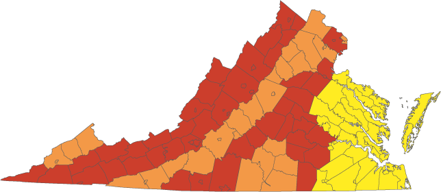
Radon zones in Virginia. Red = high potential; Orange = moderate potential; Yellow = low potential.
Modified from U.S. Environmental Protection Agency (1993).
The EPA has designated January as National Radon Action Month, a time when state radon programs conduct outreach activities and events in order to increase the public’s awareness of radon, promote radon testing and mitigation, and advance the use of radon-resistant construction practices. The Virginia Department of Health, through their Indoor Radon Program, is currently the Commonwealth’s leading source of information, technical assistance, and educational materials regarding indoor radon. They operate a toll-free number and have several publications on indoor radon that are available upon request, and they also maintain a list of companies that are certified in testing for radon, and another list of contractors for mitigation.
Maps showing radon potential for Fairfax County, Virginia, have been developed by the U.S. Geological Survey, and the citizens of the Commonwealth could greatly benefit from radon potential maps for the entire state.
Selected References:
Johnson, Stanley S., 1991, Natural radiation: Virginia Minerals, Vol. 37, no. 2.
Lafavore, Michael, 1987, Radon: the invisible threat: Rodale Press, Emmaus, Pennsylvania, 256 p.
Lasch, David K., 1988, On Radon: Virginia Minerals, vol. 34. no. 1.
Otton, J. K., Schumann, R. R., Owen, D. E., Thurman, N., and Duval, J. S., 1988, Map showing radon potential of rocks and soils in Fairfax County, Virginia: U.S. Geological Survey Miscellaneous Field Investigations Map MF-2047, scale 1:48,000.
Samet, J. M., and others, 1999, BEIR VI – Health effects of exposure to radon: National Academy Press, Washington D.C.
Schumann, R. R., and Owen, D. E., 1988, Relationships between geology, equivalent uranium concentration, and radon in soil gas, Fairfax County, Virginia: U.S. Geological Survey Open-File Report 88-18, 28 p.
United States Environmental Protection Agency, 1993, EPA Map of radon Zones: U.S. Environmental Protection Agency, Indoor Environments Division, Publication EPA-402-R-93-071, Washington, D.C.
United States Environmental Protection Agency, 2005, A citizen’s guide to radon: U.S. Environmental Protection Agency, Indoor Environments Division, Publication 402-K02-006, Washington, D.C., 16 p.
Addional Resources:
EPA report of the health effects of radon