A landslide is a downslope movement of a mass of soil, and/or bedrock material. Landslides result from a diverse assortment of ground movement processes and produce diagnostic landforms. The primary driving force for a landslide is gravity, but other factors may contribute to the failure of a slope. Landslides in Virginia are usually triggered by heavy rainfall, rapid snow melt, or oversteepening of slopes by stream incision. Human activities that alter natural slopes and water drainages can also greatly increase the likelihood of landslides. Landslides are capable of destroying buildings, knocking out power and telephone lines, and blocking transportation routes.
Some landslides move slowly, but often the movement can occur quickly and without warning. Soil creep and slumping cause property damage gradually, whereas swift-moving rockslides and debris flows can sweep away people, buildings, roads, and vehicles. In the United States, landslides kill twenty-five to fifty people and cause between $2 and $4 billion in property damage annually ( 2010 dollars).
Past landslides in Nelson and Albemarle
On the night of August 19-20, 1969, torrential rains dumped up to 27 inches of water on portions of Nelson County, southern Albemarle County, and nearby counties over a period of about 8 hours. A rare combination of moisture and circulation allowed for rapid intensification of rainfall as a weakened Hurricane Camille, having made landfall along the Gulf Coast two days prior, met air nearly saturated with moisture in the region southeast of Nelson County. Flood damage from the deluge extended all the way down the James River to Richmond, but the bulk of the affected area was in Nelson County. In addition to the flooding, hillsides in the area experienced over 7,800 landslides, typically debris flows and slides (see image below). These slides account for approximately 2,000 acres worth of damage by landslide scarring and inundation.
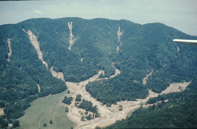
Debris flow chutes soon after Hurricane Camille, in Nelson County
The property damage and loss of life from Hurricane Camille was extensive in Virginia. At least 150 people died in the storm and flood, 125 in Nelson County alone. Property damage amounted to $140 million (1969 dollars), primarily in losses of cropland (including orchards), residences, personal property, highways, and railroads.
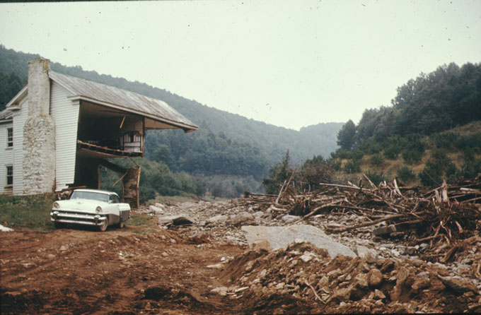
House destroyed by Hurricane Camille flood waters in the Davis Creek Community, in Nelson County
In 1995, another severe storm caused landslides in western Albemarle and Madison counties. That event caused property damage in the amount of $112 million (1995 dollars). Over 100 landslides occurred in the North Fork of the Moormans River within Shenandoah National Park. Significantly, debris from these landslides surged downstream into the Sugar Hollow Reservoir, the main water source for Charlottesville. The sedimentation from that debris reduced the reservoir's holding capacity by 15%.
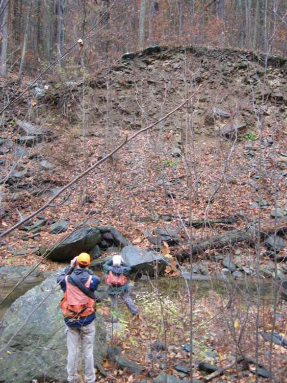
Prehistoric landslide deposit (center top) exposed at the North Fork of the Moormans River, Shenandoah National Park.
Mitigating Risk
Landslide damage poses significant risk to public health and safety, and is a recurring problem. Identifying areas prone to future landslide hazards, especially debris flows like those experienced during Hurricane Camille in 1969 and the severe thunderstorm in western Albemarle County in 1995, can help inform citizens and allow emergency personnel to target specific areas in need of early warning and evacuation procedures during future severe rainstorm events (greater than 5 inches in 24 hours).
Landslide Mapping 2019-2024
Geology and Mineral Resources received funding in 2017 and 2020 from the Federal Emergency Management Agency (FEMA) Pre-Disaster Mitigation Grant Program, through the Virginia Department of Emergency Management (VDEM) to complete a landslide hazard mapping study for Nelson and Albemarle Counties (PDMC-PL-03-VA-2017-009 and PDMC-PL-03-VA-2019-013). The study identified areas and infrastructure at greater risk for landslide initiation and inundation and and be used by local emergency management, county officials, and residents to prepare for future storm events. This mapping can also be used to improve statewide and local Hazard Mitigation Plans.
Study Area
The study area for this project included all of Albemarle and Nelson Counties, and used 1-meter 2016 lidar digital elevation data to identify historic landslide features. High resolution lidar allows for the precise identification of landslide initiation zones (headscarps) and areas that are inundated by a landslide downslope.
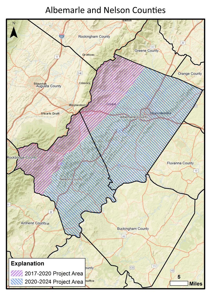
Pink hatch marks identify the extent of the study area
Methods
This project was completed in four phases:
1. Remote sensing of modern and prehistoric landslides in the study area
2. Geologic field mapping of landslide prone areas
3. Landslide susceptibility mapping and modeling
4. Presentation of data products and results to the planning community and the public.
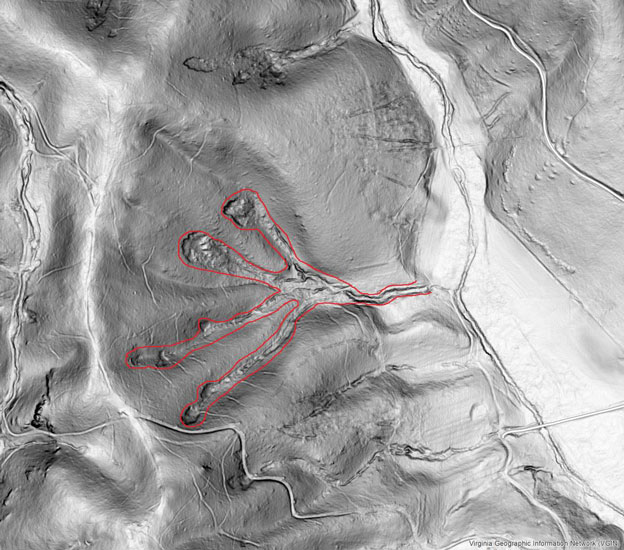
Landslide features are outlined in red in this LiDAR-derived slope-shade
basemap. These features are found in the Fortune's Cove area of Nelson County, Virginia.
Remote sensing
One-meter resolution LiDAR collected in 2016 is available for the study area from the U.S. Geological Survey. Our staff created high-resolution base maps from this publicly available LiDAR and used them to view a detailed representation of the earth’s ground surface. For more information about LiDAR, visit our webpage.
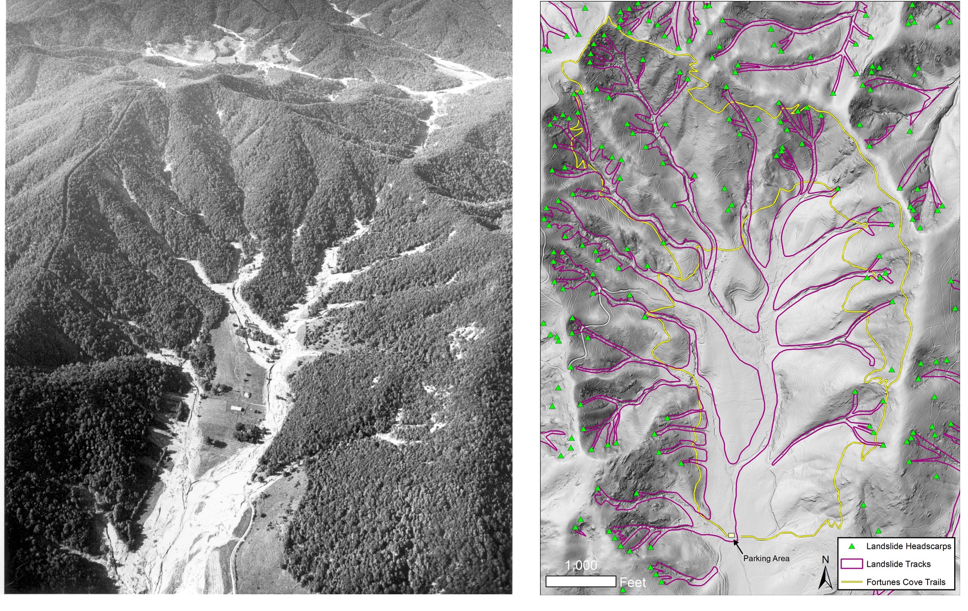
Left: An aerial view of Fortune's Cove taken days after Hurricane Camille. View to the north.
Right: Landslide features in Fortune's Cove, as they appear on the 2016 LiDAR basemap.
Using the LiDAR and several vintages of aerial photography, we visually identified pre-existing landslide features present in the study area and inventoried their location, extent, and other geomorphic characteristics. All landslide data was entered into a comprehensive ArcGIS (geographic information system) geodatabase.
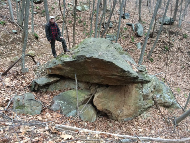
Bouldery landslide debris photographed along the upper trail in Fortune's Cove.
Field mapping
Preliminary LiDAR interpretation allows for targeted, detailed field mapping in the study area. Studying landslides up close helps geologists identify causes, model movement, determine soil properties, and constrain the geologic conditions where landslides have happened. The goal of gathering this information is to better understand where landslides are likely to occur in the future.
Landslide susceptibility modeling
Once existing landslide features were adequately mapped, geologists will use ArcGIS to identify potential landslide hazard areas. These maps will highlight at-risk areas based on factors such as slope and soil properties identified from the newly mapped pre-existing landslides in this area. The Geology and Mineral Resources Program has used similar modelling methods to produce hazard maps for other areas in western Virginia.
Deliverables
A variety of products were developed for the landslide mapping project and delivered to the Virginia Department of Emergency Management (VDEM) in September 2024. They include GIS files, maps in PDF format, outreach materials, and PowerPoint presentations. These deliverables are available for download as ZIP files and are described below.
Landslide Geodatabase (ZIP file containing an ArcGIS geodatabase):
This ZIP file contains an ESRI ArcGIS geodatabase containing point and polygon feature classes representing known landslide initiation zones (points), slope movement outlines (polygons), slope movement deposit outlines (polygons), and additional associated features. Landslide data was compiled up until the year 2024 (more recent failures will not be included). Please see the metadata for detailed descriptions of each feature class.
The download also includes map document files (.aprx) that can be used to conveniently view the GIS landslide data.
Landslide Maps(Three PDF format maps are included in the download):
1. Slope Movements and Slope Movement Deposits Map of Albemarle and Nelson Counties, Virginia.
This map illustrates the extent and distribution of known historical slope movements and pre-existing slope movement deposits mapped within the study area.
2. Landslide Susceptibility Map of Nelson and Albemarle Counties, Virginia.
This map identifies where naturally occurring slope movements may begin on otherwise undisturbed slopes in response to a major rainfall event.
3. Map of Known and Potential Debris Flow Pathways in Albemarle and Nelson Counties, Virginia.
This map delineates where debris flows may travel if they were to occur.
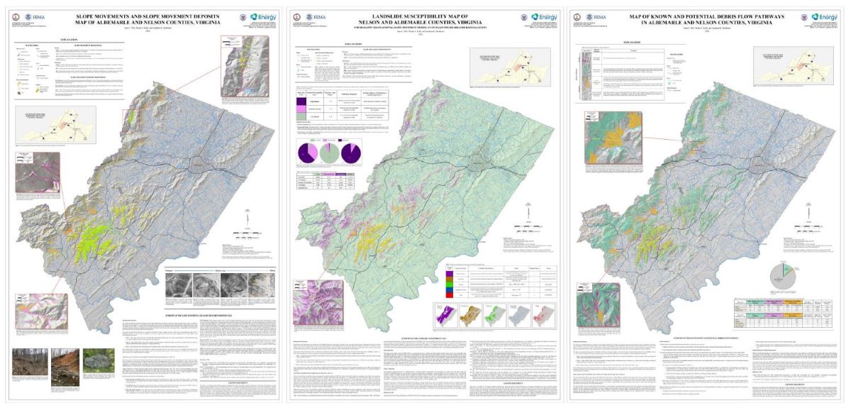
Thumbnail images of the three maps included in the project deliverable download.
Outreach Materials (ZIP file containing outreach materials and PowerPoint presentations delivered to planners and emergency managers)

Thumbnail images of the map User Guide included in the project deliverable download designed for property owners.
Acknowledgement:
This report was funded by the Federal Emergency Management Agency through the Virginia Department of Emergency Management via grant agreement number PDMC-PL-03-VA-2017-009 for $114,198 and PDMC-PL-03-VA-2019-013 for $182,764.
Other resources
What is a landslide? (USGS)
Landslides in Virginia (Geology and Mineral Resources)
Details of Hurricane Camille
Debris-flow hazards in the Blue Ridge of Virginia (USGS)
Selected References:
American Geosciences Institute, How much do landslides cost the U.S. in terms of monetary losses?: https://www.americangeosciences.org/critical-issues/faq/how-much-do-landslides-cost-terms-monetary-losses (accessed April 2019).
Boyer, John, 2019, Year of extremes: Richmond and Virginia’s biggest weather stories of 2018: Richmond Times-Dispatch, January 2nd: https://www.richmond.com/weather/year-of-extremes-richmond-and-virginia-s-biggest-weather-stories/article_a2c08eb0-07ec-5f10-b582-b66904c53a08.html (accessed Mar. 2019).
Gryta, J. J., and Bartholomew, M.J., 1989, Factors influencing the distribution of debris avalanches associated with the 1969 Hurricane Camille in Nelson County, Virginia in Schultz, A.P., and Jibson, R.W., eds., Landslide processes of the Eastern United State and Puerto Rico: Geological Society of America Special Paper 236, p. 15-28.
Morgan, B.A., and Wieczorek, G.F., 1996, Debris flows and landslides resulting from the June 27, 1995, storm on the North Fork of the Moormans River, Shenandoah National Park, Virginia: U.S. Geological Survey Open-File Report 96-503, 21 p.
Williams, G.P., and Guy, H.P., 1973, Erosional and Depositional Aspects of Hurricane Camille in Virginia, 1969: U.S. Geological Survey Professional Paper 804, 80 p.
Virginia Division of Geology and Mineral Resources, Landslides. Available at https://www.energy.virginia.gov/DGMR/landslides.shtml (accessed Mar. 2019).
Virginia Division of Mineral Resources, 1969, Natural features caused by a catastrophic storm in Nelson and Amherst counties, Virginia: Virginia Division of Mineral Resources Virginia Minerals, Special Issue, 20 p.
Witt, AC., and Whitehead, D., 2017, Fortune’s Cove and the 1969 Hurricane Camille Debris Flows: 3rd North American Symposium on Landslides field trip guide, 26 p.