What is an Earthquake ?
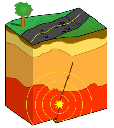
Earthquakes in Virginia commonly occur on blind faults that do not reach earth's surface.
An earthquake is the sudden release of accumulated stress within the Earth's crust that causes the ground to shake. When stress that has accumulated over time eventually exceeds the rock's strength, rupture occurs, generally along a plane of weakness called a fault. As the fault ruptures, built-up energy is released, producing undulating forces in the rock known as seismic waves. Some faults displace the ground surface, while others remain concealed underground.
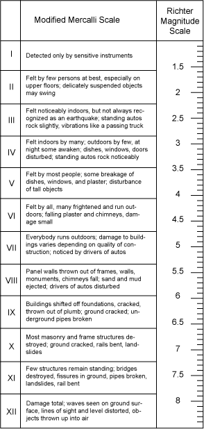
Earthquakes are measured by the amount of energy they release (Richter scale) and by the amount of damage they can cause (modified Mercalli scale)
Earthquakes vary greatly in strength. Most are small and imperceptible, and can occur almost anywhere around the world. Larger magnitude earthquakes occur less frequently but can affect thousands of square miles with disastrous results such as collapsed structures, landslides, compromised water supplies, and widespread fires from ruptured gas and electrical lines, not to mention devastated infrastructure and near-complete disruption of the local economy. Losses can run into the tens of billions of dollars.
The severity of an earthquake can be measured by either magnitude or intensity. Magnitude is the amount of energy that is released by an earthquake. Intensity is a subjective measure that describes how an earthquake affected people and structures at a particular location.
There are a number of different ways that earthquake magnitude came be calculated. Probably the most familiar is the “Richter scale,” developed by Charles Richter in 1935. Even though the original calculations developed by Richter to estimate earthquake magnitude have gone out of favor, newer formulae still retain the familiar Richter reporting methodology: a dimensionless number from 0.0 to 10.0. Currently, the moment magnitude scale (MMS) is the primary reporting method used by the U.S. Geological Survey. The MMS is a quantitative, logarithmic measure of energy released and each unit corresponds to a ten-fold increase in wave amplitude. Earthquakes less than 3.5 on this scale are generally not felt at the surface, but can be detected by sensitive instruments called seismometers. Earthquakes from 3.5 up to 5.5 are felt but there is little structural damage; above 6.0, damage increases dramatically.
The perceived intensity of an earthquake is measured using the modified Mercalli scale, which is based on qualitative descriptions, such as the type and extent of property damage, and changes in groundwater and surface water flows. The Richter scale uses Arabic numerals, while Mercalli levels are typically described using Roman numerals, with I corresponding to imperceptible events up to XII for total destruction. The Mercalli scale is a measure of the effects of an earthquake at a particular place and depends not only on the strength (magnitude) of the quake, but also the distance from the epicenter of the quake and the local geology at the observation point. Thus, a given event will have only one magnitude, but many intensity values, which tend to decrease with distance from the epicenter.
Earthquake intensity is considerably greater over soft soils than solid rock. In loose material, the shaking can increase the pressure of shallow groundwater, mobilizing sand and silt deposits, a process known as liquefaction. As a result, ground displacement increases by a factor of four or five. As the liquefied earth loses strength, buildings sink or topple over and underground utility lines rupture. Liquefaction is more likely to occur in loose, saturated granular soils with poor drainage, usually Holocene-age (less than 10,000 years old) alluvial deposits found along floodplains, or in other areas where thick, unconsolidated deposits of sand and silt have accumulated. Areas of land reclamation are often prone to liquefaction, which was a major factor in the destruction in San Francisco’s Marina District during the 1989 Loma Prieta earthquake.
Other local factors can amplify incoming seismic waves. Mountains and ridges may enhance ground vibrations by a factor of two or three as wavelengths become "tuned" to the distance between ridges. The Coastal Plain near the Fall Line is a wedge of soft sediment forming a feather edge overlying hard basement rock, and such a circumstance focuses the destructiveness of seismic waves. Many of Virginia's taller buildings are located along the Fall Line.
What Should I do in the Event of an Earthquake?
Most of Virginia's recorded earthquakes have been magnitude 4.5 or less, and the associated damage has been minor (cracks in foundation, tumbling chimneys, etc.). However, due to modern development, if Virginia experienced an earthquake with a magnitude 6.0 or greater, the consequences could be serious. Richmond, Charlottesville, Petersburg, and Lynchburg are situated on the periphery or within the Central Virginia seismic zone. A worst-case scenario would include the collapse of bridges and tall buildings, flash-flooding from breached reservoirs, widespread electrical fires and exploding gas pipelines, and potentially compromised nuclear power plants at North Anna. Damage is compounded as ruptured water lines hinder fire abatement and disrupted transportation systems delay the evacuation of seriously injured persons.
Despite the potential for a damaging earthquake in the future, few engineering studies or emergency response plans have been devised specifically for our region. Studies of features left by prehistoric earthquakes, called paleoseismology, can reveal a great deal about what to expect in the future. Further research into the geologic control of earthquakes in Virginia could greatly lessen the impact of a destructive event by 1) improved predictability and characterization of damages, and 2) delineation of earthquake-susceptible substrates in urban areas such as Richmond, as well as for situating critical emergency response facilities throughout the state. The typical homeowner's insurance policy does not cover damage from earthquakes.
What earthquakes have occurred in Virginia?
See a real-time feed of the seismograph located at our Charlottesville office »
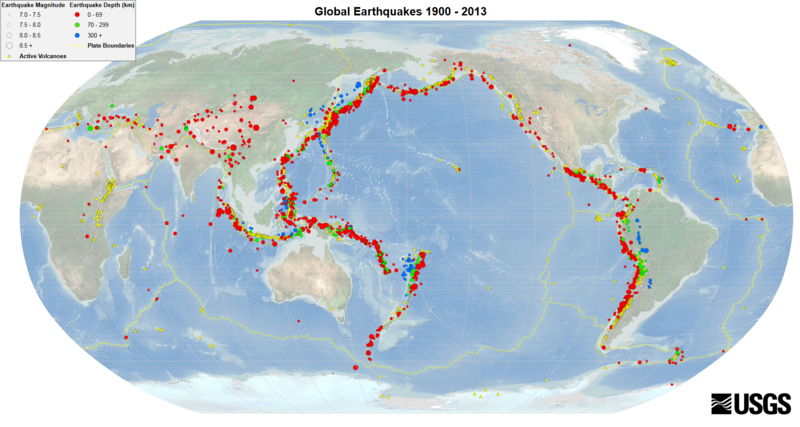
Earthquakes are extremely common along tectonic plate boundaries, but also occur at passive continental margins, such as the eastern United States.
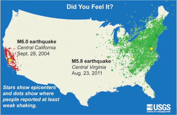
Most earthquakes occur along tectonic plate boundaries where stress is greatest. Unlike the West Coast, the East Coast is situated near the center of a tectonic plate and resides on what geologists call a passive margin. This is not to say that earthquakes don't occur in Virginia, but they are much different than the earthquakes that occur in California. West Coast earthquakes can be very shallow and often break the ground surface, while in Virginia they usually occur at depths of anywhere from three to fifteen miles and it is not always possible to associate a specific earthquake with a specific fault. In general, East Coast earthquakes are less energetic than those on the West Coast, but due to the coherency of the basement rock (think concrete slab vs. brick patio) they are felt much farther away. In Virginia, the affected area can be up to ten times larger than it would have been for a similar magnitude event occurring in the western United States.
James R. Martin II, former director of the Earthquake Engineering Center for the Southeastern United States, has said, “Recent seismological studies suggest that the southern Appalachian highlands have the potential for even larger earthquakes than have occurred in the past. But now those events would take place in much more highly populated areas.” He believes that “we are under a significant threat of large, damaging earthquakes.” Martin goes on to say that earthquakes don’t occur as often in the East as they do along the West Coast because the tectonic strain rates are different and our region “tends to experience large earthquakes isolated by long periods of quiet.” There’s another difference. “The earth’s crust is stronger here,” explains Martin Chapman, director of the Virginia Tech Seismological Observatory. “So shock waves moving from the epicenter of an earthquake don't lose as much energy as during quakes in California. When a magnitude 7.0 earthquake occurs in the Southeast, the waves affect a larger area and can cause more damage at a greater distance than when a similar shock hits California.
Earthquake activity in Virginia has generally been, with a few exceptions, low-magnitude but persistent. The first documented earthquake in Virginia took place in 1774 near Petersburg, and many others have occurred since then, including an estimated magnitude 5.5 (VII) event in 1897 centered near Pearisburg in Giles County. A Roanoke attorney who was in Pearisburg said that for nearly fifty miles from that place he saw hardly a sound chimney standing. In his opinion, If the buildings throughout Giles had been largely of brick, the damage would have been very great, and serious loss of life would have occurred. The largest recorded earthquake in Virginia occurred in Louisa County on August 23, 2011 and had a magnitude of 5.8 (VII). It was felt all along the eastern seaboard by millions of people, causing light to moderate damage in central Virginia, Washington, D.C. and into southern Maryland. Since 1977, more than 195 quakes have been detected as originating beneath Virginia. Of these, at least twenty-nine were large enough to be felt at the Earth's surface. This averages out to about six earthquakes per year, of which one is felt.
Find out more about major earthquakes that have occurred in Virginia.
The August 23, 2011 Magnitude 5.8 Mineral, VA Earthquake
At 1:51 p.m. eastern daylight time on Tuesday, August 23rd 2011, the most damaging earth¬quake ever felt in Virginia was recorded. According to the U.S. Geological Survey, the epicenter of the quake was in central Virginia near the town of Mineral, in Louisa County. Approx¬imately 150,000 individuals reported feeling the earthquake through the U.S. Geological Survey Earthquake Hazard Program, "Did You Feel It?" website . The earthquake was felt over the entire eastern United States and into Canada, potentially making it the earthquake felt by more people than any other in United States history.
Scientists have determined that the Mw 5.8 shock was actually a complex earthquake of three subevents. Faulting initiated approximately four miles underground and progressed upward and to the northeast. The rupture occurred along a previously unknown fault, now named the Quail Fault, but did not break the ground surface. The northeastward progression of rupture may account for the fact that ground motions were much stronger to the northeast, toward the Washington, D.C. area, as compared to shaking experienced in other directions from the epicenter.
The U.S. Geological Survey reports that the August 23, 2011 earthquake was the most widely-felt earthquake in U.S. history.
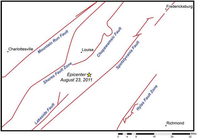
Location of the epicenter of the August 23, 2011 earthquake and the locations of mapped faults at the Earth's surface.
The 2011 earthquake occurred along a fault that has no surface expression.
Geologists from our Geology and Mineral Resources Program (GMR) and the U.S. Geological Survey gathered immediately following the earthquake to record intensity measurements across the area. From the data collected GMR created damage intensity maps (below). Some homes in the epicentral area were shifted off of their foundations, had chimneys that toppled, and sustained damage to exterior and interior walls and framing. Total damages resulting from the 2011 earthquake reached at least $300 million. Eight counties in Central Virginia were included in the federally-declared disaster area; Louisa County alone received almost 1,500 damage reports from residents. The entire Louisa County school system closed down for weeks following the earthquake, and two schools were considered damaged beyond repair.
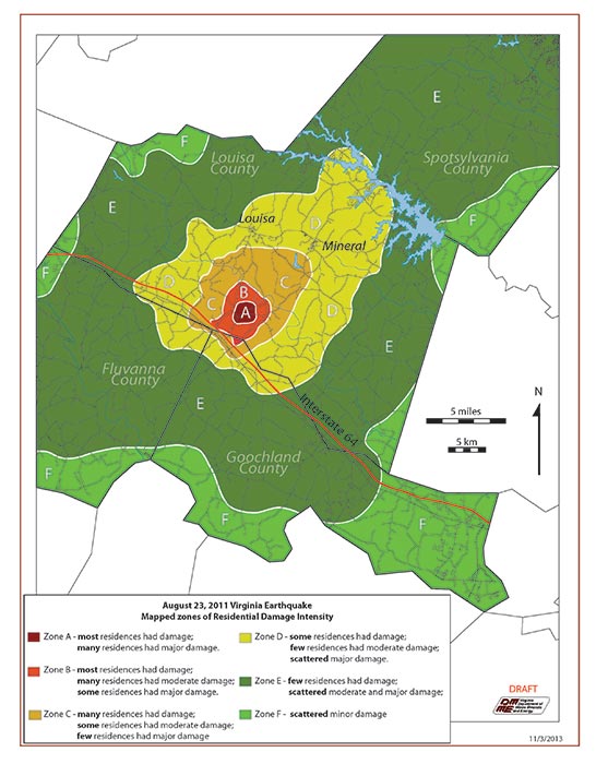
Damage Zone Intensity map for the 5.8M Earthquake (click on image to view full size line)
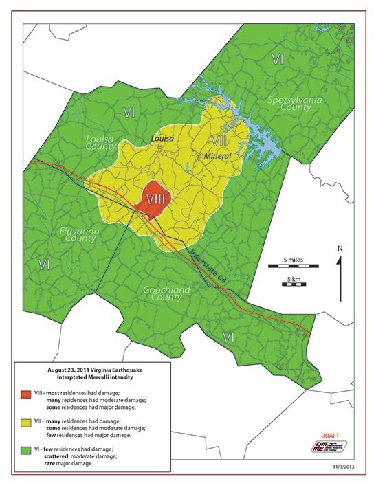
August 23, 2011 Virginia Earthquake Interpreted Mercalli intensity (click on image to view full size line)
Virginia's Seismic Zones
Virginia's past seismic activity is concentrated in three primary areas: the Central Virginia seismic zone (CVSZ), the Giles County seismic zone (GCSZ), and the Eastern Tennessee seismic zone (ETSZ). The CVSZ is located within the central Piedmont along the James River and includes the counties of Fluvanna, Goochland, Cumberland, Powhatan, Louisa, Albemarle, Buckingham, Hanover, and Chesterfield, and the cities of Richmond and Charlottesville. The GCSZ is along the New River Valley in Giles County, and extends to the southwest, and includes parts of Pulaski, Bland, Wythe, Montgomery, Grayson, and Carroll Counties. The ETSZ stretches from northern Alabama and Georgia north through eastern Tennessee and includes a small portion of far southwestern Virginia in Lee County. Although these three seismic zones delineate the greatest concentration of earthquake events that have occurred in Virginia, all parts of the Commonwealth should be considered susceptible to earthquake shaking, as the entire state has experienced seismic activity in the past.
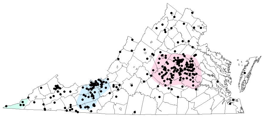
This map shows the locations of known earthquake epicenters in Virginia.
The Eastern Tennessee seismic zone is shown in green, the Giles County seismic zone is shown in blue
and the Central Virginia seismic Zone is shown in pink.
The exact mechanisms of Virginia's earthquakes are not clearly understood. The Piedmont has been assembled piece-by-piece through geologic time and is laced with numerous faults of varying ages. Residual stress may cause these faults to reactivate on occasion, but patterns are unclear. The Giles County seismic zone may be associated with the Narrows Fault, the Saltville Fault, and/or an extension of the Holston Valley Fault, or all three. These faults trend toward eastern Tennessee, which is one of the most seismically active areas in the continental U.S.
The epicenter of the 2011 5.8M Mineral earthquake falls within the Central Virginia Seismic Zone. Several known faults are present in the area: the Chopawamsic Fault, the Lakeside Fault, and the Spotsylvania Fault. These are old faults, related to plate tectonic events that closed and then reopened the Atlantic Ocean about 200 million years ago. Even though these faults are quite old and considered to be inactive, occasional earthquakes continue to occur.
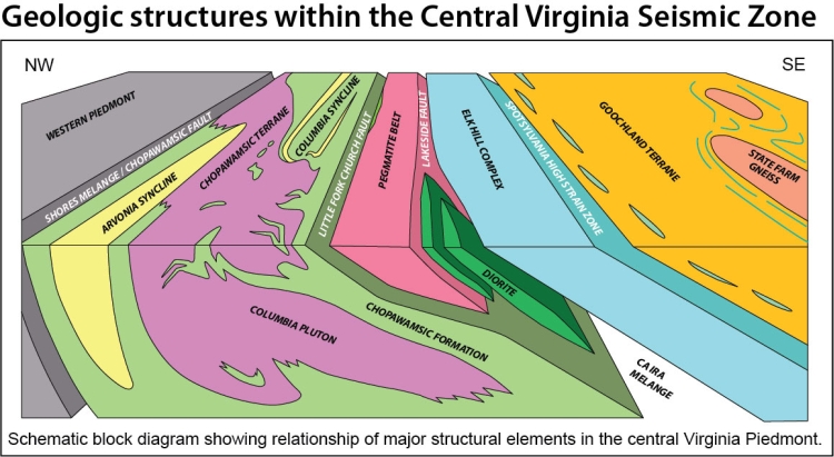
Geologic structures within the Central Virginia Seismic Zone, Virginia Department of Energy
Geology and Mineral Resource's Publication 66 is an interpretation of the seismic profile line along Interstate-64 in Central Virginia. This publication proves helpful in showing the fault structure of the Central Virginia Seismic Zone. Interpretation by geologists on the image below shows several scallop faults in an overthrust regime. Using two way travel time, the small red bounding box shows the proposed location 3.5 miles southwest along-strike of the 5.8M earthquake.

Interpreted 2-D seismic line along I-64 across the Central Virginia Seismic Zone (Publication 66 ) (click on image to view full size line)
Earthquake Monitoring and Mapping
The Virginia Tech Seismological Observatory (VTSO) is one of the primary sources for data on seismic activity in the central East Coast. In 1963, as part of the worldwide program, seismometers were installed at Blacksburg. In 1977, several more seismometers were stationed in the Commonwealth and operated by the Virginia Division of Geology and Mineral Resources. Along with the Center for Earthquake Research and Information (CERI) and the U.S. National Seismic Network, VTSO contributes to seismic hazard assessment in the southeastern United States and compiles a Southeastern U.S. Earthquake Catalog.
In 2014, the Geology and Mineral Resources Program received a 3-year Federal Emergency Management Agency (FEMA) funded grant to identify and map faults in the seismically active regions of Virginia, including the Central Virginia and Giles County seismic zones. This project was completed in 2017. Deliverables included an ArcGIS geodatabase of faults and earthquake locations, a report on Virginia's earthquake history (Publication 185), a general earthquake hazard assessment, and outreach materials for planners and emergency management.
Click here to learn more about this study and to download project deliverables.
Selected References:
Bollinger, G. A, 1978, Seismic Hazard in Virginia: Virginia Minerals, Vol. 24, no. 4.
Bollinger, G. A, 1981, The Giles County, Virginia, seismic zone — configuration and hazard assessment in J. E. Beavers, editor, Earthquakes and earthquake engineering: The Eastern United States, vol. 1, Ann Arbor Science Pub., Inc., Ann Arbor, Michigan, p. 277-308.
Bollinger, G. A., and Sibol, M. 1985, Seismicity, seismic reflection studies, gravity and geology of the central Virginia seismic zone; Part I, Seismicity: Geological Society of America Bulletin, v. 96, p.49-57.
Bollinger, G. A., Snoke, J. A., Chapman, M. C., and Sibol, M. S.,1989, Estimates of the occurrence and resulting effects of damaging earthquakes in Virginia: Virginia Minerals, v. 35, n. 3.
Bollinger, G. A., Johnston, A. C., Talwani, P., Long, L. T., Shedlock, K. M., Sibol, M. S., and Chapman, M. C., 1991, Seismicity of the southeastern United States: 1698 to 1986 in Neotectonics of North America, Geology of North America Decade Map Volume, p. 291-308.
Coruh, C., Bollinger, G. A., and Costain, J. K. 1988, Seismogenic structures in the central Virginia seismic zone: Geology, v.16, p.748-751
Kelly, W.S., Witt, A.C., Heller, M.J., and Chapman, M.C., Seismic history of Virginia: Virginia Division of Geology and Mineral Resources Publication 185, 24p.
Mixon, R. B. and Newell, W. L., 1977, The Stafford fault system-structures documenting Cretaceous and Tertiary deformation along the Fall Line in northeastern Virginia: Geology, v. 5, p. 437-440.
Paliser, L. C., 1991, Earthquakes: U. S. Geological Survey pamphlet, 20 p.
Spears, D. B., and Bailey, C. M., 2002, Geology of the central Virginia Piedmont between the Arvonia syncline and the Spotsylvania high-strain zone: 32nd Virginia Geological Field Conference Guidebook, 36 p.
Stover, Carl W., and Coffman, Jerry L., 1993, Seismicity of the United States, 1568- 1989, USGS Professional Paper 1527.
Additional Resources:
Earthquake Hazard Mapping Project
College of William & Mary Geology of Virginia Web site, details of the 2011 earthquake
ScienceBlog, “Virginia earthquake not a fluke in the seismically active Southeast.”
The USGS Earthquake Hazards Program
Virginia Tech Seismological Observatory
Site with map showing earthquakes in the eastern US within the last six months