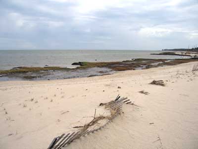
Haven Beach, Mathews County: The current beach sands sit on top of,
and behind marsh deposits. In 1981, this beach was about 200 feet east (into Chesapeake Bay) of its current location; the effect of rising sea level and storm
activity moves many beaches landward under natural conditions.
Coastal flooding usually occurs when a major hurricane makes landfall. The abnormal height of sea level, often called a storm surge, is the result of a combination of factors. The storm’s extreme low pressure allows sea level to rise, so a mound of water forms beneath the storm center, where its height is directly related to the drop in barometric pressure — roughly a 10 mm increase in sea level for every millibar drop in atmospheric pressure. Wind-driven waves ride on top of this mound, building the height of the water mass. The stage of the tide when the storm arrives is another contributing factor.
Hurricanes are the most common type of catastrophic natural disaster along the East Coast and Gulf Coast, with one or two making landfall each year, on average. Coastal flooding coupled with high winds can devastate everything in the hurricane’s wake — homes, vehicles, and landscaping — while flooding septic systems and contaminating drinking water supplies. Many people underestimate the forces involved and become victims. On September 8, 1900, a Category Four hurricane struck Galveston, Texas, and the storm surge killed between 6,000 and 12,000 people, making it the deadliest natural disaster ever to hit the United States. The second deadliest occurred when a hurricane pushed Lake Okeechobee over its banks on the night of September 16, 1928, drowning over 2,500 people in their sleep. The “New England Hurricane of 1938” swept a movie theater two miles out to sea, drowning the patrons and the projectionist. In the United States, the highest storm surge on record was generated in 2005 by Hurricane Katrina, which exceeded twenty-seven feet where it made landfall near the Louisiana/Mississippi border. Katrina was the third deadliest storm in U.S. history; with 1800 killed and damage exceeding $81 billion it remains America’s most expensive natural disaster.
During severe storms, damage is not just limited to flooding, but also involves shoreline erosion from increased wave activity, undermining and destroying buildings, roadways, and utility lines. Scouring floodwaters can excavate bridge supports and foundations, thus compromising highways and railroads. The extent of erosion is related to a number of factors: composition of the shoreline (rock, sand, clay, marsh, or man-made structures), fetch, orientation to prevailing wind direction, and relative sea-level rise. Additionally, there is the localized effect of land subsidence, and flood heights can vary by several feet over the Tidewater area, given basin shape, wind direction, and state of the tide.
The Commonwealth of Virginia is regularly struck by hurricanes and tropical storms. The Hampton Roads/ Virginia Beach/Norfolk area has taken direct hits from a Category Three hurricane in 1944, Hurricane Connie in 1955, and Hurricane Donna in 1960. In addition, large swaths of Virginia experienced torrential rain and flooding from Camille in 1969, Agnes in 1972, Juan in 1985, and Fran in 1996.
The hurricane of 1933, widely known as the “storm of the century” for the Chesapeake Bay, brought extensive coastal flooding. This hurricane generated a storm surge in Hampton Roads of 5.8 feet. In 2003, Hurricane Isabel generated a 4.7 ft storm surge, and although a foot lower than the 1933 storm, many long-time Tidewater residents say that Isabel’s coastal flooding was worse, probably due to a global rise in sea level: in Tidewater sea level has risen 1.35 feet between 1933 and 2003. Virginia Institute of Marine Science emeritus professor Dr. John Boon warns that sea-level rise will continue to exacerbate coastal flooding during future storms. “The inference from Isabel is very clear,” he says. “Other things being equal, our present sea level trend will, over time, significantly increase the risk of coastal flooding during hurricanes.”
Virginia's coastal zone includes 5,000 miles of tidal shoreline — much of it containing desirable sites for homes — and sixty percent of Virginia’s population lives in coastal areas. However, homeowners insurance does not cover flood damage so it is expedient to obtain appropriate coverage. The Federal Emergency Management Agency provides information about the National Flood Insurance Program at their FloodSmart web site.
Numerous Virginia State agencies address coastal problems. Prominent among them is the Virginia Institute of Marine Science (VIMS), which provides research and advisory services.
The Virginia Department of Environmental Quality (VDEQ) is the lead agency for the Virginia Coastal Zone Management Program, a voluntary partnership between the National Oceanic and Atmospheric Administration and coastal states, authorized by the Coastal Zone Management Act.
The Virginia Marine Resources Commission is also involved in the regulation and permitting of construction along shorelines. Virginia’s Erosion and Sediment Control Law, administered by the Department of Conservation and Recreation (DCR), requires soil-disturbing projects to be designed to reduce erosion and to decrease sediment input into the Chesapeake Bay. DCR’s Shoreline Erosion Advisory Service promotes environmentally acceptable erosion control measures to protect private property and reduce sediment in the Chesapeake Bay. In addition, the program promotes research for improved shoreline management techniques.
Additional Resources:
Sea-Level Rise and Virginia's Eastern Shore
Center for Coastal Resources Management (VIMS)
Shoreline Studies Program (VIMS)
News release from VIMS: “Rising Sea Level Increases Hurricane Risk.”
Virginia Department of Environmental Quality Coastal Program