
|
Your Price: $0.00
Model
Number: 3050
|
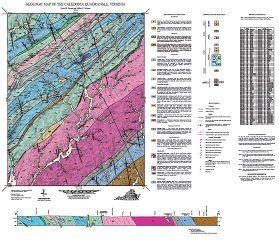
By D.B. Spears and J.D. Murray, 34 x 38-inch color 1:24,000-scale geologic map, 2013. This map of the Caledonia 7.5-minute quadrangle in Fluvanna, Goochland, and Louisa counties, Virginia shows the distribution of Mesozoic-age igneous rocks and Paleozoic to Proterozoic-age metamorphic rocks in map and cross-section. Modern alluvium and river terrace deposits are shown. A table listing historical mine sites in the area is provided. Online only.
|
|