HyperLink
Sign In Sign In Sign Out Logout Account Account Cart Cart
 
  SEARCH    Help?         Why do we use cookies?       Privacy Policy/Disclaimer
    Home

Product Categories


Sales & Returns Policy


Spacer Image

Spacer Image
Spacer ImageOpen File Report 11-09 Bedrock Geologic Map of the Luray Quadrangle, Virginia
Spacer Image Spacer Image
Spacer Image
Spacer ImageYour Price: $0.00
Spacer ImageModel Number: 3039

Spacer Image
Spacer Image
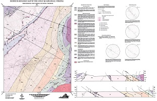
By J. Drummond, O.P. Shufeldt, and S.J. Whitmeyer, 30 x 44-inch color 1:24,000-scale geologic map, 2011. This map of the Luray 7.5-minute quadrangle in Rockbridge County, Virginia shows the distribution of Paleozoic-age sedimentary rocks and Paleozoic- to Proterozoic age metamorphic rocks in map and cross-section. Stereonet plot of structural data are also provided. Online only.
Spacer Image