
|
Your Price: $0.00
Model
Number: 2872
|
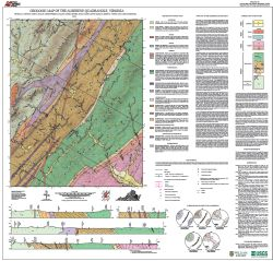
By Johnson, T.A., Hollis, J.S., Bailey, C.M., Jensen, A., Hahn, M., Quinlan, K., Owens, B.E., and Marshall, A., 36- x 38-inch color 1:24,000-scale geologic map, 2014. This map of the Alberene 7.5-minute quadrangle in Albemarle County, Virginia shows the distribution of Proterozoic, Paleozoic, and Mesozoic age igneous, metamorphic, and sedimentary rocks. Surficial deposits and quarries are also shown. Four geologic cross-sections are included. The general geology of the area and the characteristics of each map unit are described. Publication 180. Online only.
|
|