
|
In Stock
Your Price: $6.00
Model
Number: 1009

|
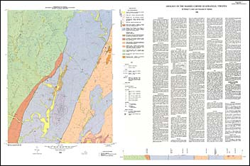
by M.T. Lukert and C.R. Halladay, geologic map with map text, scale 1:24,000, 1980. This map shows the bedrock geology and surficial deposits of the Massies Corner 7.5-minute quadrangle and includes a discussion of the area’s stratigraphy, structure, and economic geology. The quadrangle lies in the core of the northeastward-plunging Blue Ridge anticlinorium and includes portions of Rappahannock, Culpeper, and Fauquier counties. The bedrock mapped in the area consists of Precambrian gneisses and granites of the Robertson River Formation and the Flint Hill Gneiss, as well as other igneous and metamorphic units that are informally named. Also mapped are Triassic dikes and unconsolidated alluvial sediments. Quarries and rock repository locations are plotted on the map and a cross-section is included.
|
|