
|
Out of Stock
Your Price: $6.00
Model
Number: 1208
|
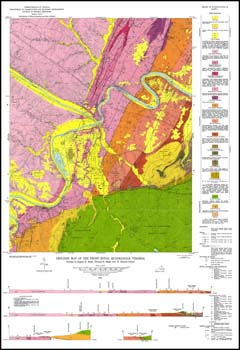
E.K. Rader, T.H. Biggs, 6 x 9-inch soft cover book, 91 pages, two pllates includes two folded 23 x 34-inch color 1:24,000-scale geologic maps, 21 figures, seven tables, 1975. This report and the accompanying maps portray and describe the stratigraphy, structure, economic geology, hydrogeology, and environmental geology of the Front Royal 7.5-minute quadrangle in Warren County. Blue Ridge cover rocks, Valley and Ridge sedimentary rocks and recent alluvium are mapped in the area. Quarries for limestone and shale are shown on the geologic map. Plate 2 groups geologic formations into environmental units that have similar characteristics and similar benefits and hazards with regard to land use. Several stratigraphic sections and a road log for the area are included.
|
|