HyperLink
Sign In Sign In Sign Out Logout Account Account Cart Cart
 
  SEARCH    Help?         Why do we use cookies?       Privacy Policy/Disclaimer
    Home

Product Categories


Sales & Returns Policy


Spacer Image

Spacer Image
Spacer ImageReport of Investigations 025: Geology of the Bristol and Wallace quadrangles, Virginia
Spacer Image Spacer Image
Spacer ImageIn Stock
Spacer ImageYour Price: $6.00
Spacer ImageModel Number: 1193

Spacer Image
Spacer Image
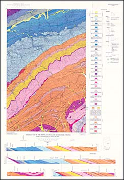
by C.S. Bartlett, Jr. and H.W. Webb, 93 p., map in color, 22 figs., 3 tables, 1971. Map shows the geology and mineral resources of the Bristol and Wallace 7.5-minute quadrangles. These quadrangles are located in Washington County in southwestern Virginia. They are entirely within the Valley and Ridge physiographic province. The bedrock in these quadrangles ranges from Lower Cambrian through Upper Mississippian and including Ordovician, Silurian, and Devonian rocks. Major structural features in this quadrangle include parts of the Greendale and Beaver Creek synclines and the Saltville, Pulaski-Staunton, Spurgeon and Bristol fault blocks. Crushed limestone is the primary mineral resource in the map area. Map includes cross-sections.
 Customers who bought this also bought
  Publication 016: Geology of the Abingdon, Wyndale, Holston Valley, and Shady Valley Quadrangles
  Publication 167: Selected Karst Features of the Southern Valley and Ridge Province, Virginia
  Publication 065: Geology of the Norton Quadrangle, Virginia
  Bulletin 022: Geology and Coal Resources of Russell County, Virginia
  Bulletin 026: Geology and coal resources of the coal-bearing portion of Lee County, Virginia
 
Spacer Image