HyperLink
Sign In Sign In Sign Out Logout Account Account Cart Cart
 
 
   Help?         Why do we use cookies?       Privacy Policy/Disclaimer
    Home

SURVEY

Product Categories


Sales & Returns Policy

Mastercard LogoVisa Logo


Spacer Image

Spacer Image
Spacer ImageReport of Investigations 040: Geology of the Front Royal quadrangle, Virginia
Spacer Image Spacer Image
Spacer ImageVirginia Energy Mineral Logo Spacer Image
Spacer ImageIn Stock
Spacer ImageYour Price: $6.00
Spacer ImageModel Number: 1208

Spacer ImageAdd to Cart
Spacer Image
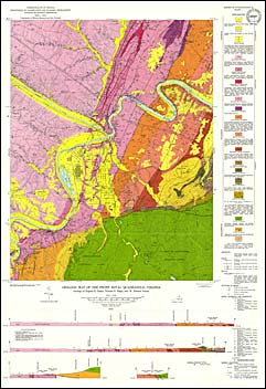
by E.K. Rader and T.H. Biggs, with a section on Hydrogeology by R.H. DeKay, 91 pages, 2 maps in color, 21 figures, 7 tables, 1975. Map shows the geology and mineral resources of the Front Royal 7.5-minute quadrangle. Front Royal quadrangle is located in Warren County, northern Virginia. It lies mostly within the Valley and Ridge physiographic province but approximately 20 percent is within the Blue Ridge physiographic province. The bedrock in this quadrangle ranges from Precambrian through Ordovician in age. Major structural features in this quadrangle include the southeastern limb of the Massanutten synclinorium and an overthrust salient of the Blue Ridge anticlinorium. Crushed limestone is the primary mineral resource in the map area. Map includes cross-sections.
 Customers who bought this also bought
  Report of Investigations 045: Geology of the Strasburg and Toms Brook Quadrangles, Virginia with a Section on Hydrogeology by R.H. DeKay
  Geologic Map Of Virginia (1:500,000)
  Publication 060: Geology of the Harrisonburg and Bridgewater Quadrangles, Virginia
  Publication 138: Geologic Map of Warren County, Virginia
  Report of Investigations 044: Geology of the Linden and Flint Hill Quadrangles, Virginia with a Section on Hydrogeology by R.H. DeKay
 
Spacer Image