
|
In Stock
Your Price: $6.00
Model
Number: 1023

|
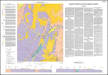
by B.K. Goodwin, geologic map with map text, one sheet, 1981. The Glen Allen 7.5-minute quadrangle is at the extreme eastern edge of the Piedmont physiographic province and lies astride the Fall Zone, which separates the igneous and metamorphic rocks of the Piedmont from the sediments of the Coastal Plain province. Nonmarine sand, clay, and gravel overlie eroded Piedmont lithologies in the eastern quarter of the area at the edge of the Coastal Plain proper. A small portion of the Triassic lowland subprovince occurs in the quadrangle as a narrow basin of Triassic sedimentary rocks. Deep weathering of crystalline and of Triassic sedimentary rocks has produced a deep residual soil that is thickest on hilltops and thinner on slopes. Bedrock outcrops are rare except along streams. In addition to describing the lithologies of the area, there are also sections on economic and environmental geology.
|
|