
|
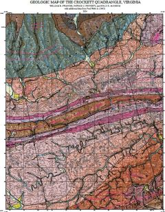
Open File report 2025-21 Geologic map of the Crockett quadrangle, Virginia, 1:24,000-scale
|
|
|
Your Price: $0.00
Model
Number: 3126
|
By W.R. Swanger, P.C. Finnerty, and H.E. Mangum, 41 x 48-inch color 1:24,000-scale geologic map, 2025. This map of the Crockett 7.5-minute quadrangle in Wythe County, Virginia shows the distribution of Paleozoic-age sedimentary rock of the Max Meadows, Pulaski, and Saltville thrust sheets in map and cross-section. Modern alluvium, river terrace, and slope deposits are also shown. Online only.
|
|
|
|