
|
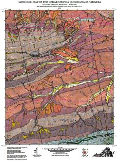
Open File Report 2025-16 Geologic map of the Cedar Springs quadrangle, Virginia, 1:24,000-scale
|
|
|
Your Price: $0.00
Model
Number: 3112
|
By W.R. Swanger and A.J. Merschat, 38 x 44-inch color 1:24,000-scale geologic map, 2025. This map of the Cedar Springs 7.5-minute quadrangle in Smyth, Wythe, and Grayson Counties, Virginia shows the distribution of Paleozoic-age sedimentary rocks of the Pulaski, Max Meadows, and Laswell thrust sheets structurally below the Holston Mountain fault, which transports Neoproterozoic- to Mesoproterozoic-aged rocks of the Blue Ridge Basement Complex in map and cross-section. Modern alluvium, river terrace, and slope deposits are also shown. Online only.
|
|
|
|