
|
Out of Stock
Your Price: $6.00
Model
Number: 1035
|
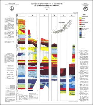
D.C. LeVan, E.K. Rader, folded 42 x 36.5-inch color stratigraphic chart, 1983. Generalized stratigraphic sections for six northeast/southwest trending areas in the western part of Virginia in Valley and Ridge and Appalachian Plateaus with gas and oil production/occurrence zones show for each. Starting in the Appalachian Plateaus and progressing east, sections depict the following stratigraphic range: Section 1 - fault below the Lower Cambrian Rome Formation through Middle Pennsylvanian Harlan Sandstone, Section 2 - Lower Cambrian Shady Dolomite through Upper Mississippian Pennington Formation, Section 3 - fault below the Lower Cambrian Rome Formation and Elbrook Formation through Upper Mississippian Maccrady Formation, Section 4 - fault below Lower Beekmantown Formation through Lower Mississippian Brallier Formation, Section 5 - Lower Cambrian Unicoi Formation through Upper Devonian Knobs Formation and Paperville Shale, Section 6 - Lower Cambrian Unicoi Formation and Swift Run Formation through Upper Devonian Mahantango Formation. Also included is a correlation of drillers' terms to stratigraphic units for the Appalachian Plateaus.
|
|
|
|
Customers who bought this also bought
|
Publication 023: Geologic Structure and Hydrocarbon Potential along the Saltville and Pulaski Thrusts in Southwestern Virginia and Northeastern Tennessee
|
Geologic Map Of Virginia (1:500,000)
|
Publication 144: Geology, Natural Gas, Oil, and Other Mineral Resources of Wise County, Virginia
|
Publication 153: Coal, oil and gas, and industrial and metallic minerals industries in Virginia, 1998
|
Bulletin 056: Early Grove gas field, Scott and Washington counties, Virginia
|
|
|
|