HyperLink
Sign In Sign In Sign Out Logout Account Account Cart Cart
 
  SEARCH    Help?         Why do we use cookies?       Privacy Policy/Disclaimer
    Home

Product Categories


Sales & Returns Policy


Spacer Image

Spacer Image
Spacer ImagePublication 143: Geologic Map of Clarke, Frederick, Page, Shenandoah, and Warren Counties, Virginia: Lord Fairfax Planning District
Spacer Image Spacer Image
Spacer ImageIn Stock
Spacer ImageYour Price: $8.25
Spacer ImageModel Number: 1265

Spacer Image
Spacer Image
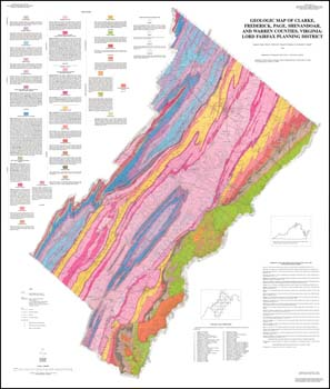
by E.K. Rader, R.C. McDowell, T.M. Gathright, II, and R.C. Orndorff, folded 41 x 48-inch color 1:100,000-scale map, 1996. Shows Blue Ridge and Valley and Ridge stratigraphy and structure in Clarke, Frederick, Page, Shenandoah and Warren Counties. Geologic data from 45 7.5-minute quadrangles were compiled at 1:100,000-scale to produce this map. List of references used in the compilation included.
 Customers who bought this also bought
  Bulletin 080: Geology and Mineral Resources of Frederick County
  Publication 102: Geologic Map of Clarke County, Virginia and Map of Selected Hydrogeologic Components for Clarke County, Virginia
  Publication 138: Geologic Map of Warren County, Virginia
  Publication 162: Geologic Map of the Front Royal 30 x 60-minute Quadrangle: Portions of Clarke, Page, Rockingham, Shenandoah, and Warren Counties, Virginia
  Geologic Map Of Virginia (1:500,000)
 
Spacer Image